


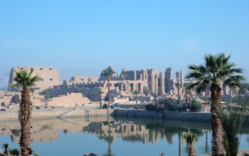
A groundbreaking geoarchaeological study has revealed the foundational secret of the Karnak Temple Complex, showing it was built on a sacred island that emerged from the Nile, a landscape that mirrored ancient Egyptian creation myths. The research fundamentally rewrites our understanding of how one of the ancient world’s most magnificent temple complexes came to be.
Research Rewrites History
The research, led by the University of Southampton and Uppsala University and published in Antiquity, provides the most comprehensive analysis ever conducted of the UNESCO World Heritage site. By drilling 61 sediment cores and analyzing tens of thousands of pottery fragments, the international team has pieced together a dramatic geological and archaeological history that pushes back the timeline of Karnak’s earliest occupation.
An Island in the Nile
The study’s data reveal that before approximately 2500 B.C., the area was a dynamic, riverine environment regularly flooded by fast-flowing Nile channels. They found that prior to about 2520 BCE, the site would have been unsuitable for permanent occupation due to being regularly flooded by fast-flowing water from the Nile. Contrary to previous assumptions, the temple was not built on a simple riverbank but on an island of high ground, created as Nile channels carved deeper beds to the east and west. This newly identified eastern channel was found to be more significant than previously thought, potentially even larger than the western one.
Dating the Dawn of Karnak
The sediment evidence places crucial new constraints on when major development at the site began. The findings indicate the earliest sustainable occupation of the Karnak precinct likely occurred during the Old Kingdom, spanning from around 2591 to 2152 B.C. This geological timeline is firmly supported by the archaeological record. “The ceramic fragments we found align perfectly with the sediment data, with the earliest pieces dating from between 2305 and 1980 B.C.,” said Dr. Kristian Strutt, a co-author from the University of Southampton. “This gives us a much clearer picture of the temple’s infancy.”
Where Landscape Meets Myth
The most profound implication of the research lies in the striking parallel between the physical landscape and ancient Egyptian religious belief. Central to Egyptian cosmology was the concept of the “primeval mound”—the first patch of earth to emerge from the endless, chaotic waters at the dawn of creation. This mound was where life began and where the creator god first manifested. The new survey suggests the island upon which Karnak was built was the only such area of high ground surrounded by water in the entire Theban region.
A Divine Blueprint
For the ancient Theban elites, this natural island would have represented a terrestrial embodiment of sacred myth. “It’s deeply compelling to suggest that Theban elites intentionally chose this location because it physically mirrored their cosmogonical texts,” Dr. Pennington explained. “They were building the dwelling place for a new form of the creator god, Amun-Ra, on a spot that literally represented the moment of creation.” Each year, as the annual Nile flood receded, the mound of Karnak would reappear, reenacting this divine emergence from the “Waters of Chaos.”
The study not only charts the geomorphic evolution of one of the world’s great archaeological treasures but also offers a rare glimpse into the ancient Egyptian mind, revealing how the interplay of land, water, and belief conspired to create a religious capital that would endure for millennia. The research team now plans to extend its work across the entire Luxor floodplain, seeking to map the sacred waterscape of the entire ancient Egyptian Theban realm.